The Allocation
Phoenix isn't running out of water. It's running out of cheap water, and the cost is landing at the edge of the city

This is the eighth essay in The Heat Ledger, a series about the physical systems Phoenix negotiates every day.
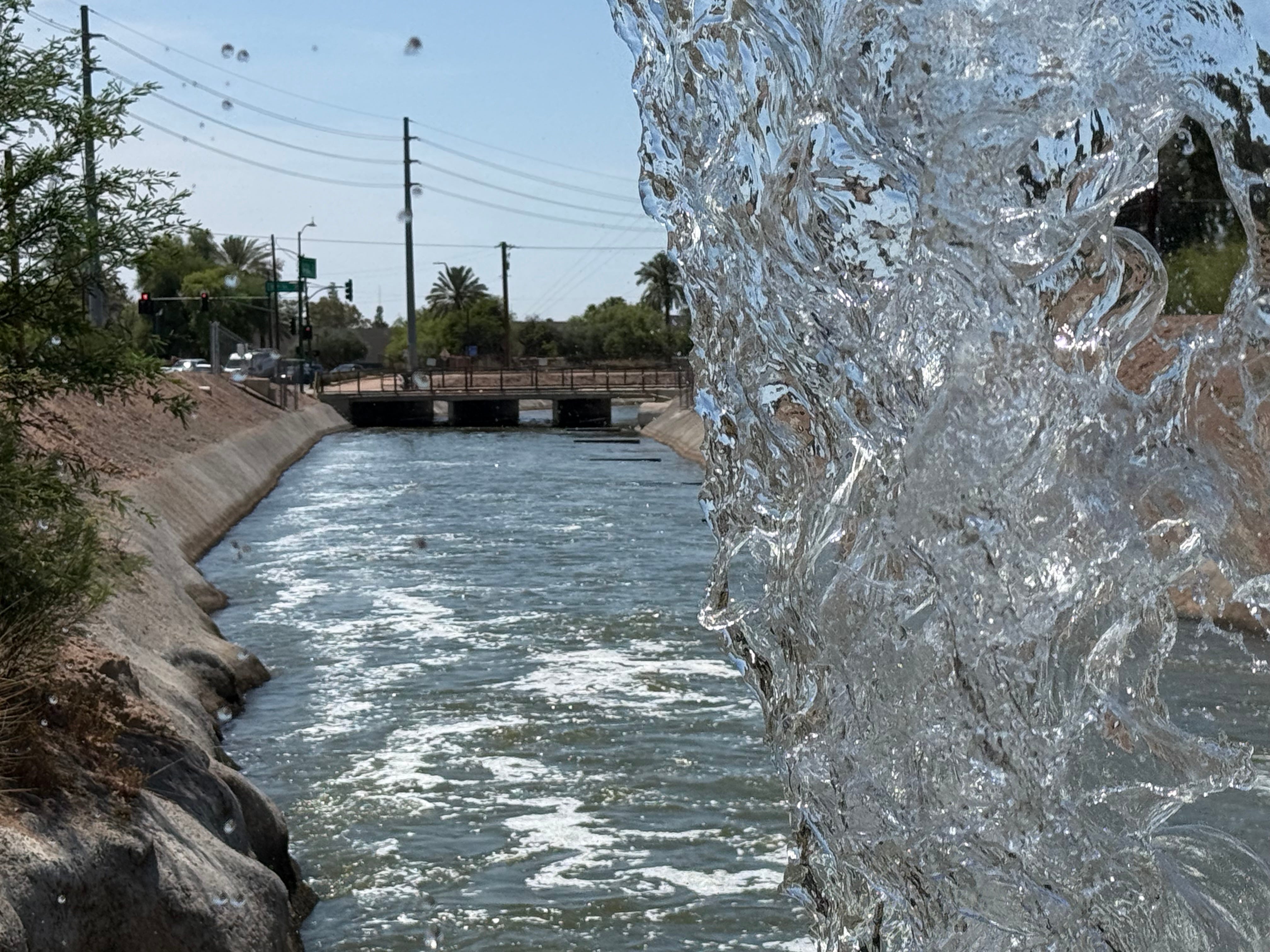
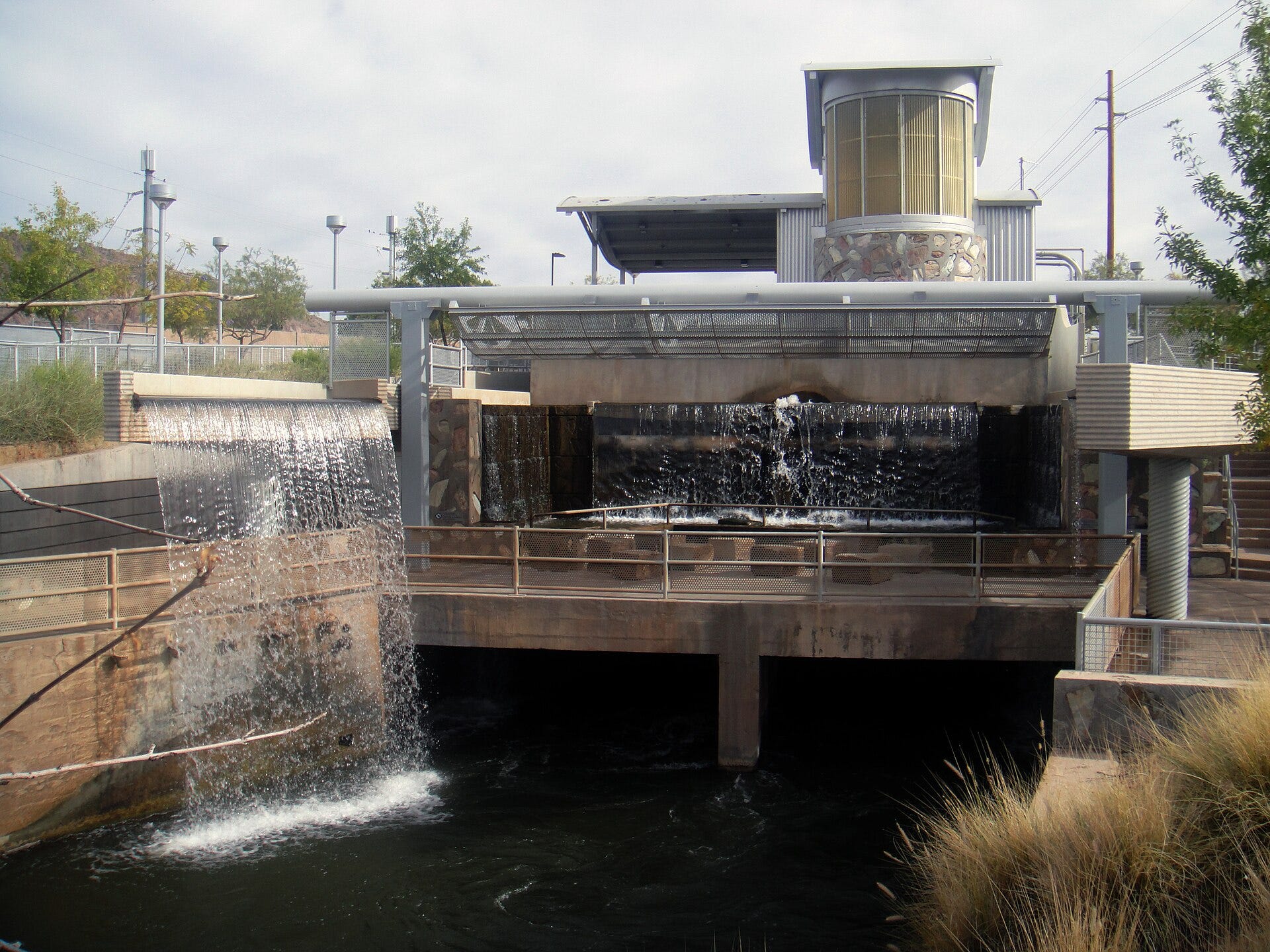
Stand on the footbridge at Arizona Falls and the first thing is the sound.
Twenty feet of water going over a ledge, in a desert, in a city that catches eight inches of rain in a good year. The cool lifts off it even in July. You feel it before you decide to. Below, the canal runs flat and green-brown toward the next bridge, toward Indian School, where the cars do not slow down.
The falls look like they have always been here. They have not, and they are not natural. They are an accident of excavation. In the 1880s, crews digging the Arizona Canal hit a ledge of hard rock, a stubborn drop in the desert floor, and instead of blasting it level, they let the water fall.
The accident became a place. People came to picnic, to swim, to dance. A cool spot, back when coolness was something you went outside to find.
Phoenix stopped needing the falls the same way it stopped needing to think about where the water comes from.
The water in the canal is not “Phoenix water” in the simple local sense. And it is mostly not Colorado River water either.
For the City of Phoenix (the political city, plus about half of Paradise Valley), the tap water breaks down like this: roughly 60 percent originates as Salt and Verde River water, delivered through the Salt River Project. A little under 40 percent originates as Colorado River water. A very small amount is groundwater, pumped from local wells. That is the portfolio. The number that gets cited in most coverage (41 percent groundwater, 36 percent Colorado, the rest split) is the statewide figure, the whole of Arizona averaged together. It is not Phoenix. Phoenix is its own arrangement, and the arrangement is unusual.
Kathryn Sorensen ran Phoenix Water Services from 2013 to 2021, the utility that delivers tap water to well over a million people. She now directs research at the Kyl Center for Water Policy at ASU’s Morrison Institute. If Phoenix were running out of water, she is the person who would have known first. She put the spine of it plainly: the snowpack in central and eastern Arizona (the Mogollon Rim, the White Mountains) is what comes out of the tap in Phoenix. The Salt and the Verde, fed by that snow, are the river the city actually drinks. The Colorado is the supplement. Real, necessary, but not the center.
This runs against almost everything written about Phoenix from a distance. The national story points at the Colorado: at Lake Mead’s white bathtub ring, at the apocalyptic frame in which Phoenix is the city about to go dry. The frame is not invented. The Colorado is in trouble. But the camera is pointed at the supplement, not the spine.
The water is here because someone fought for it early, and the falls are where you can see the fighting start.
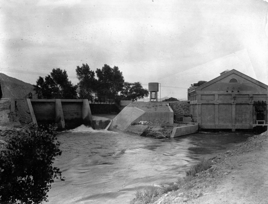
Over the winter of 1901, Phoenix Light and Fuel Company built a hydroelectric plant at the falls. The company promised it would have “no equal between St. Louis and Los Angeles.” The Salt River Project rebuilt and took it over in 1913, and it ran until 1950. Then the site faded, not because the water left, but because the city’s cool places moved indoors. A power plant and one of the city’s earliest places to take a date both existed because nobody wanted to dynamite a rock.
A year after the plant, in 1903, valley farmers put their land up as collateral to the federal government to build a dam on the Salt River. They had been living at the mercy of the river, flooded out one year, dry the next. Pledging their land to finance Roosevelt Dam was the seed of the Salt River Project. The water security Phoenix now takes for granted began as a group of farmers betting everything they owned that engineering could outlast weather.
Then comes the part most people never learn, the part that makes Phoenix strange.
The Salt River system runs on prior appropriation, where the water belongs to the land. You cannot move it. And as the valley urbanized, as the cotton and alfalfa fields became subdivisions, something counterintuitive happened. It takes roughly six acre-feet of water a year to farm an acre of cotton in this sun. It takes about one to run a subdivision on the same acre. So as the farms became houses, total water use fell. But because the water belongs to the land, the “saved” water could not be picked up and sold to new development somewhere else. It stayed in the system. It sat in the reservoirs.
Sorensen called it a demand-capped, under-allocated, resilient system. The Salt River Project used to deliver about 1.5 million acre-feet a year when the valley was farmland. It now delivers roughly half that. The demand fell and the supply could not chase new growth, so it banked. The same law that trapped the water on the land is the law that saved it.
That is the exact structural opposite of the Colorado River, which was over-allocated on paper a century ago and has been short ever since.
Was Phoenix lucky or aggressive? Both, Sorensen said. And the second part matters more. Yes, it helped to plant the city on a well-governed, resilient river. But the city kept choosing the durable thing. It expanded capacity on the Verde at Bartlett Dam during the war years. “That wasn’t good luck,” she said. “That was foresight.” And it guarded its groundwater like a savings account it refused to touch. “Phoenix has been very conscientious about trying not to dip into its savings account,” she said, drawing on renewable surface water instead, holding the aquifer in reserve for a drought that might run for decades. Rivers run high and then run low. If you steward the groundwater, you survive the low. Phoenix stewarded the groundwater.
The falls are the visible inch of a system built on being early.
Who wasn’t at those tables.
This is not a story of villains. The farmers who pledged their land did what the law told them to do. But arriving early is the whole story in Western water, and arriving late is its own kind of sentence.
In 2023, the Arizona Department of Water Resources found that the groundwater beneath the Phoenix area’s edge could not support all the future growth that had been promised against it. The aquifer was, in effect, already spoken for. The state stopped approving new subdivisions that wanted to prove a 100-year water supply on groundwater alone. On paper, the finding covered the whole Phoenix groundwater basin. In practice, it bit only where new development was trying to prove its hundred years on groundwater alone, out past the cities that already held a designation of assured water supply. Phoenix proper never felt it; it had done the expensive work decades ago. The places that did were the ones still reaching for the cheapest water under them.
The 1980 Groundwater Management Act, Sorensen said, was astonishing legislation. It tied the right to subdivide and grow directly to a 100-year water supply, a bar she has never seen another state match. And special interests began trying to chip away at it almost immediately. The story of the Act is the story of a high bar and a steady pressure to lower it.
That pressure is live right now. The homebuilders, represented by the Goldwater Institute, sued, arguing the state had changed how it judged groundwater availability without going through formal rulemaking. In April 2026, a Maricopa County judge agreed and struck the restriction down, finding the department had “unilaterally” rewritten its process while pretending the rule had always been that way; the state said it would appeal. And in 2025, with bipartisan majorities, the legislature passed and the governor signed an “Ag-to-Urban” program: a farmer can permanently give up an irrigation right and turn part of that retired groundwater use into a credit a developer can use to satisfy the 100-year assured-water-supply test nearby. The state built a legal channel for turning farms into subdivisions. The freeze is not a settled fact. It is a fight, and the fight is happening now.
The reason is cost. Drilling a well is the cheapest water a developer can get, a couple million dollars and the water is right there underfoot. Building the alternative (acquiring renewable surface water, laying the infrastructure, constructing a surface-water treatment plant) runs to fifty million and up. The 2023 ruling did not tell developers they could not build. It told them they could not build on the cheapest possible water. Developers run profitable businesses; they build houses families want; they look for the cheapest path. It is the system doing what systems do.
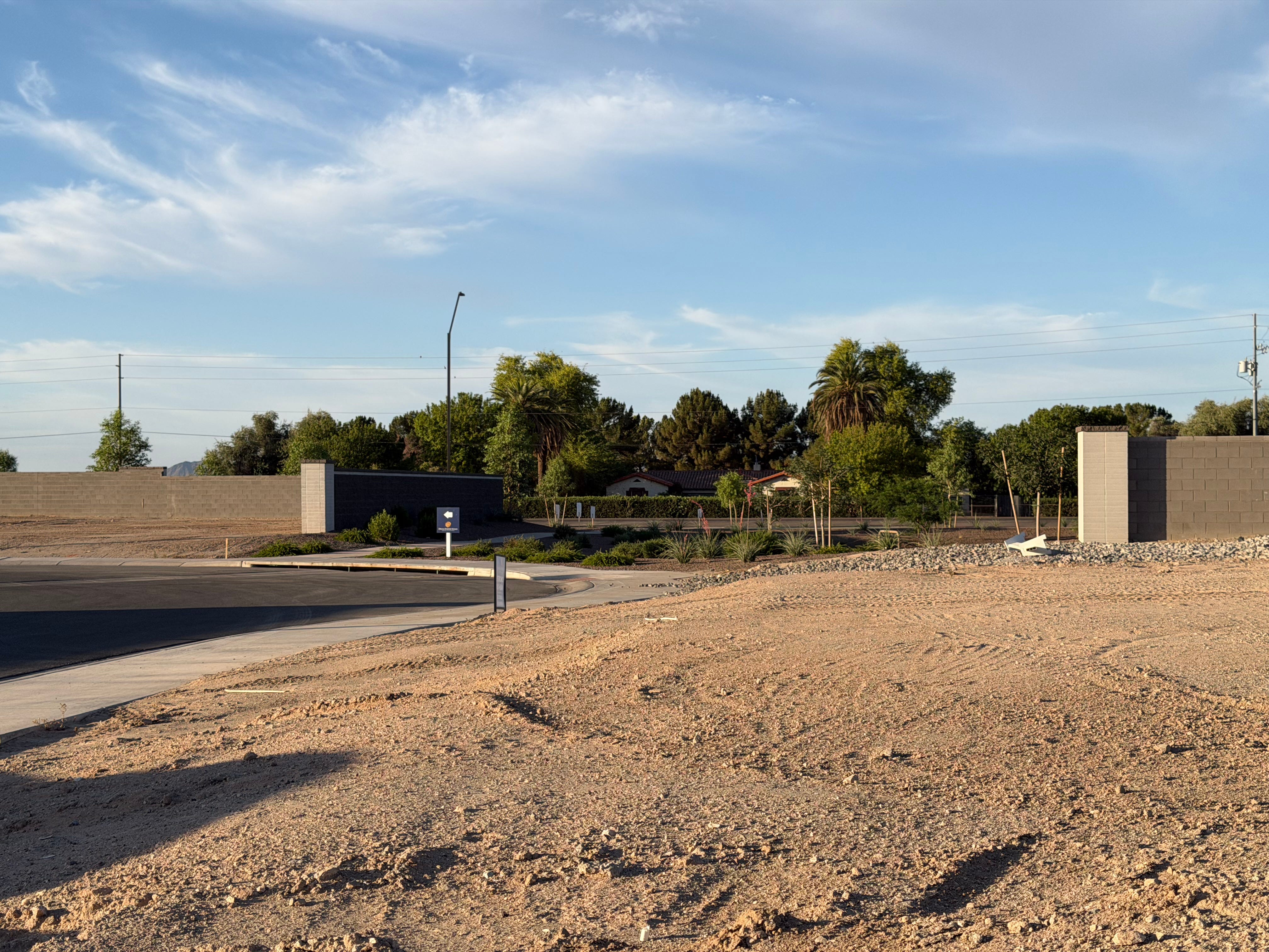
You can stand in the place where that sorting has already finished. Out past the western edge, off Apache Road in Buckeye, there is a farmhouse, Spanish-style, red tile roof, lush behind a hedge and a stand of old trees, on a wide green parcel that still looks like the farm it used to anchor. It is occupied. It is also the last living thing on its block. Every field that once surrounded it has gone to dirt. On one side, mounds of graded earth and the first framed houses of a subdivision the builder calls Apache Farms. On the other, more dirt, more grading, the entrance monument already up for the next one. The farm the farmhouse belonged to is gone. The house remains, like a tooth in an empty gum.
The shortage is real. The camera is pointed the wrong way. The cost falls where it isn’t looking.
The line between the city that locked in its water and the fringe that didn’t is not a hydrological line. It looks like a zip code, a school district, a mortgage rate. It is one more way the valley sorts risk outward, toward the edge, toward the people who arrived after the water was already spoken for.
And underneath all of it, the oldest unfinished business: the rights that predate every table. Prior appropriation rewards whoever used the water first, and the people who used it first were here for generations before 1903. The Akimel O'odham and the Pee-Posh — the Pima and Maricopa — were farming this water when the first canals were dug, on a system their Hohokam predecessors had worked for a thousand years before them. In the late nineteenth century their stretch of the Gila was cut off by diversions and dams built upstream by farmers who came later, and the farming life it sustained nearly ended with it. Recognition came in 2004. The Arizona Water Settlements Act gave the Gila River Indian Community a water budget of 653,500 acre-feet a year, resolving claims to more than a million acre-feet, and including a 311,800 acre-foot Central Arizona Project entitlement, the largest in the state, larger than the City of Phoenix’s own. The oldest claim in the watershed was among the last to be honored. The water has only lately begun returning to the dry bed, and the birds have come back to it. “The land started to heal itself,” the Community’s governor, Stephen Roe Lewis, has said. That is the compressed version of a much longer story, and it deserves the longer one.
Phoenix did not escape scarcity. It allocated it.
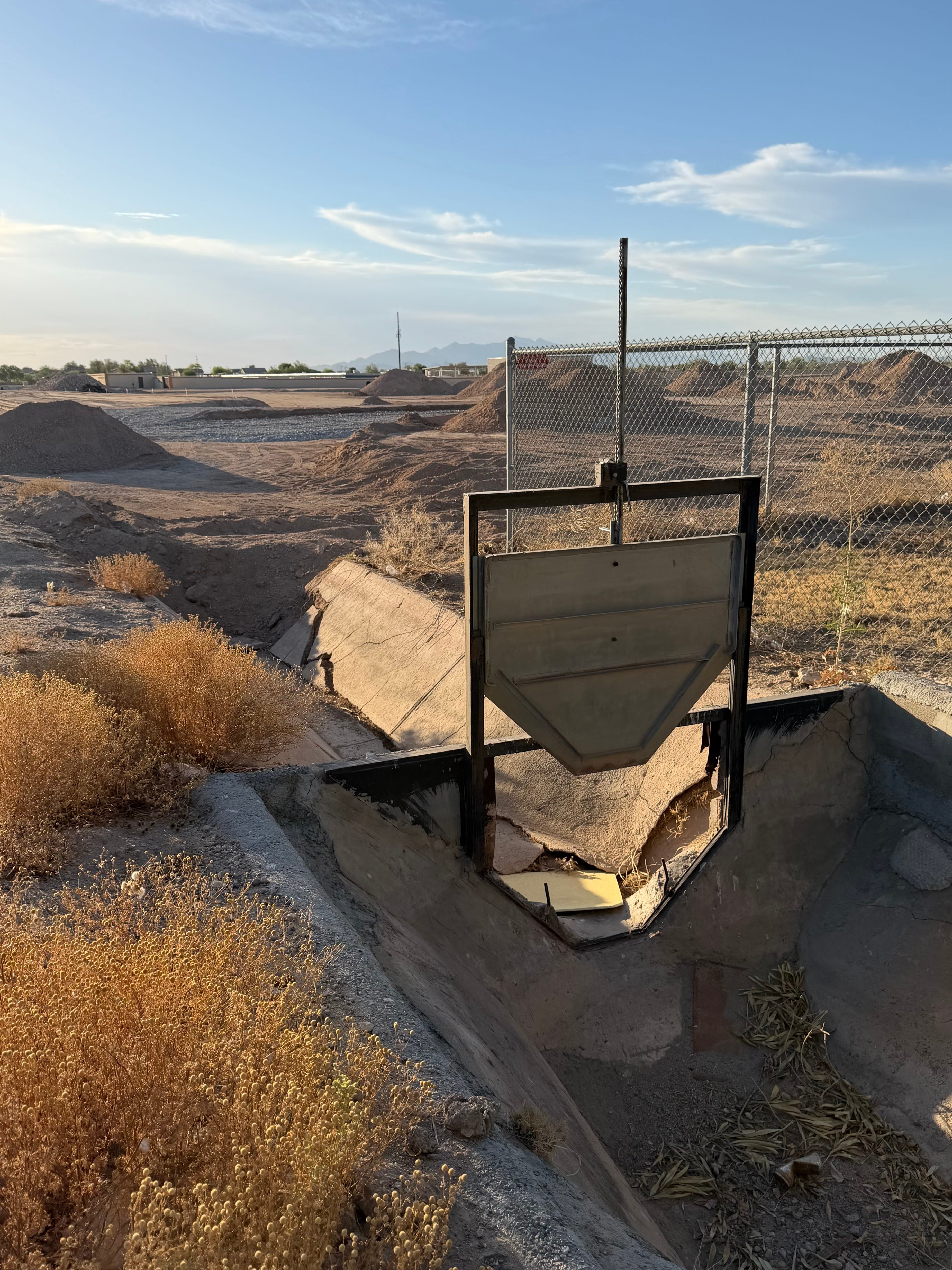
Across the road from that farmhouse, an irrigation gate sits in a concrete ditch. It is the kind of head gate that once let a farmer pull water off a lateral and send it down his rows, a steel plate in a frame, a channel running to the fields. The fields are gone, so the gate has nothing left to do. It still stands anyway, a steel plate in a frame, while the channel it fed lies smashed and dry below it. Nothing has run through it in a long time, because there is nothing left to run it to. A little after six on a June morning, the heat already coming up off the dirt, you can stand at that broken gate and smell alfalfa and cattle on the air, carried from the farms that haven’t died yet, a few sections over, glimpsed between the new rooflines. That is the shape of it out here now. Not a few subdivisions dropped into the farmland. A few farms left in the middle of the houses.
Drive the few sections to the living fields and the air changes. It is cooler over irrigated ground. You feel it through the open window. A degree or two by feel, more on a thermometer. The water that grows the alfalfa also cools the air above it. Take the water away, scrape the field to dirt for lots, and the heat comes up where the crop used to be. The same water does both jobs. You only notice the second one when it stops.
The rules are running out. The 2007 operating guidelines were written to carry the river through the 2026 operating year, and the seven basin states still have no replacement deal. Even now the seven states are signing memoranda to explore swapping water across their borders, the early architecture of whatever comes next. The most recent was signed in June 2026 — at a desalination plant in Carlsbad, California.
A paper Sorensen co-authored this June lays out the arithmetic. In a dry year, the gap between what the basin uses and what the river provides could push the major reservoirs toward a system crash: run-of-the-river, the storage gone. But a crash does not mean the taps run dry in a city like Phoenix. The diversified cities fall back on what they built. The first and hardest cost lands on agriculture, which is where most of the basin’s water actually goes. In Arizona the imbalance is starker: irrigated agriculture uses about 72 percent of the state’s water, while the on-farm sector accounts for less than half a percent of its economy, most of that water growing forage and cotton, not food. The apocalypse narrative gets complicated by that fact without being disproved by it.
Sorensen has a phrase for the gap between what the law promises and what the river holds: paper water versus wet water. Whatever comes out of the ground is wet water, physical, real. On paper it can wear five different legal labels depending on the authority you used to pump it. The two are sometimes the same and very often not. Her frustration, after a career in this, is that the policy world understands the paper and not the wet: the entitlement, not what it takes to deliver the water the entitlement names.
Phoenix is rich in wet water its peers are not, and it built the expensive machinery to keep it flowing. When Sorensen arrived in 2013, she had the engineers model what losing the Colorado supply outright would do. The answer, she said, was “nothing good”: roughly 400,000 people in north Phoenix, served by two treatment plants that run on the river, would be cut off from tap water. Her first instinct was to drill wells on the banked groundwater, but the distribution system had been built for a few big surface-water sources, not dozens of scattered wells, and the hydraulics would not carry it. So the city built the Drought Pipeline Project instead, a transmission main to push Salt and Verde water to those plants. It was finished in December 2022, at a cost of $280 million.
The ratchet still tightens. The river loses ground in the dry years and never fully recovers in the wet ones, and the baseline drops a little each cycle. “Phoenix isn’t running out of water,” Sorensen said. “It’s running out of cheap water.” The next supplies — expanding Bartlett Dam to catch more of the Verde, advanced purification that turns wastewater back into drinking water — work, and cost a fortune. Humans have been moving water from where it is to where they need it for thousands of years. It has never been free, and it is about to get expensive in a way the valley has not had to feel before.
The running-out story, she said, is “clickbait” — ill-informed, and pointed at the wrong danger. The real one is water becoming much more expensive, and the risk of serious groundwater depletion if the whole valley has to pump harder to cover lost Colorado supply. The aquifer she spent a career guarding could carry Phoenix for decades, generations even, but only if it is stewarded, and there is enormous pressure from developers and others to do the opposite, because it is cheap.
Phoenix bought itself time. The mistake would be confusing time with innocence.
Back on the footbridge. The water still drops over the ledge that should have been blasted away. The accident still performs.
The city rebuilt this site in 2003, a working hydroelectric plant again, and a piece of public art, with Alberto Ríos’s words cut into the deck. Of all the places water moves through Phoenix (the canals, the laterals, the treatment plants, the buried mains), this is the one the city chose to put on a stage. The one place you are meant to stop and look at the water.
And most people don’t. They speed down Indian School Road with the windows up and the air running, past the one spot in the city engineered to remind them where the water comes from, on their way somewhere the question never comes up.
Only the falling water is visible: bright, loud, cool in the heat, going over a ledge nobody meant to leave.
I get that grass makes things feel cooler but it's not native to North America. Mowed grass tends to be full of chemicals which leech into storm drains. I see wasted potable water flowing with a current in the gutter of my neighborhood every day. One neighbor even has moss. I took out my grass and planted all natives and I have had 24 species of butterflies in my yard plus solitary bees and other needs and so much diversity then ever before. We are losing habitat. We need to rebuild it and plant native trees where ever we can. I also have rain barrels to use potable water. 70% of water use in a home is out doors filling chemically filled pools and watering chemically filled grass. We need to stop. Most water in the state is used watering high water use plants like cotton and alfalfa. That need to stop.
Dr. Doug Tallamy says there are 40 million acres of grass in the US and National Monument are around 50 million acres. Why? All the grades work they way into the deserts and parks and are chocking out native plants and contributing to fire risk. We need to rethink landscaping.